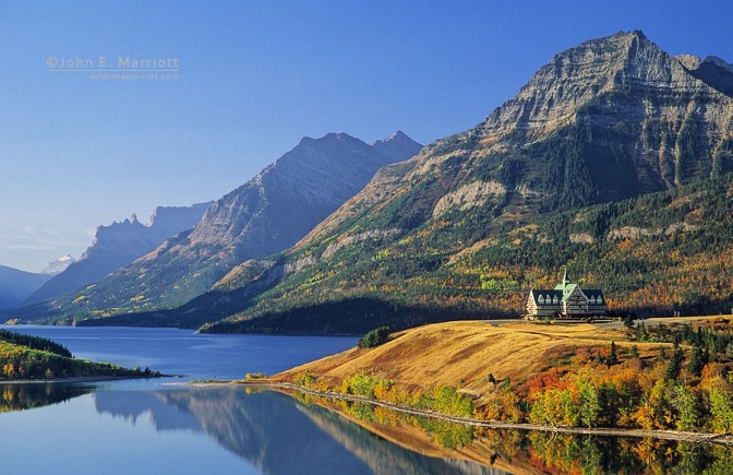
At Waterton Lakes National Park – a landscape of perpendicular mountains and deep, glacial lakes on the eastern edge of the Canadian Rockies – the wind was a living thing. Parked on The Bosphorous, a promontory overlooking Upper Waterton Lake, I felt it clutching my car as if invisible banshees were trying to get in. The peaks around the lake – some resembled broken stumps of teeth, others the prows of great stone ships – stood firm against the wind. Rafts of cloud lumbered across the sky. The highest tops snagged the clouds, tearing them open and releasing sheets of rain.
 The 2½ hour drive south from Calgary had taken me across a seemingly endless expanse of rippling prairie. Elsewhere in Alberta, the prairies rise slowly to the mountains through rolling stretches of foothills. But Waterton’s peaks seemed to erupt from the landscape, like sea cliffs from the ocean. One minute I was crossing the prairie; the next I was encircled by mountains with the sky compressed into a narrow crack above me.
Everyone who visits Waterton Lakes National Park does so by choice. This quiet corner of Alberta, far from main highways and transcontinental railways, is the end of the road. You can’t go any further unless you want to hike. The park encompasses 525 square kilometres of mountains, lakes, forests and prairie. With neighbouring Glacier National Park, across the border in Montana, USA, Waterton forms the Waterton/Glacier International Peace Park. Established in 1932, the Peace Park was the first in the world to span an international border: symbolizing friendship between nations and the need for countries to share resources.
Though an international boundary divides the two parks, Waterton/Glacier functions as one ecosystem. Water and air flow freely in both directions. Animals and birds use both parks in their annual cycles of migration, breeding and foraging.
More than 220km of trails amble through the park, ranging from short strolls to multi-day wilderness treks. Designated trails cater for horse riders and mountain bikers. In winter, walking track and roadway alike become cross-country ski trails. Upper Waterton Lake – the deepest lake in the Canadian Rockies – freezes over and it’s possible to ice-skate from Waterton Townsite (the park’s only village) all the way to Goat Haunt at the head of the lake, 6.4km inside Montana.
It was late November, the last month of Fall. At Waterton Townsite, trees wore their autumn finery: rich golds, earth browns and pale lime-greens. Piles of leaves gathered around shuttered summer cottages and tumbled in the wind along Waterton Avenue. A couple of sleek mule deer stags sparred on the lawn of the Royal Canadian Mounted Police post.
“It can get kinda breezy here at this time of year,” park ranger Locke Marshall told me as we sat in his office at Park Headquarters. Outside, the howling Chinook hurled leaves horizontally against the window. It slashed at the surface of Upper Waterton Lake raising curtains of spray.
“This is nothing,” he added, continuing the understatement. “Days without wind are unusual here and gusts of 160 kilometres per hour are common.”
I had come to the park to explore the landscape my great uncle, the explorer and adventurer Thomas Wright Blakiston, had discovered 130 years before. I wanted to see the waterfall and stream named after him and climb to the 2920 metre (9646 feet) summit of Mt. Blakiston. Locke Marshall smiled knowingly and glanced outside at the shrieking wind when I told him I wanted to climb the mountain.
“Forget it,” was his advice. He also warned me not to hike alone. Autumn is bear season and a close encounter with a black bear was something I didn’t want, he told me.
I arranged lodgings in the Olde Worlde comfort of Kilmorey Lodge – feather beds, creaky wooden floors, antique furniture – then set off along a winding road leading up the Blakiston Valley. The citadel summit of Mt. Blakiston towered overhead. From the head of the valley a trail led to Blakiston Falls, through a forest of Lodgepole Pine and Engelmann Spruce. Hiking alone in the creaking forest was eerie. Was I being scrutinized through the trees by an irritable bear? My imagination created a watching Bruin from every shadow and the growl of a wolf from every noise.
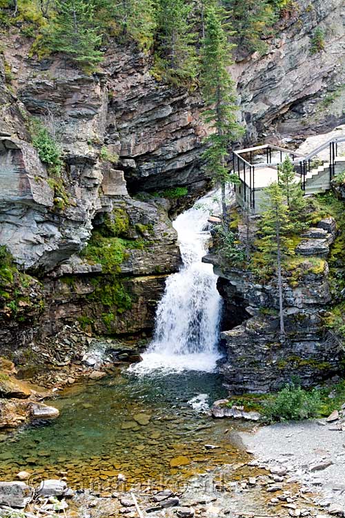 At Blakiston Falls, the crystal waters of Blakiston Stream stepped down through a series of rapids and tumbled over the 12m high falls, en route to the Hudson Bay, 1300km to the east. I sat on a rough wooden bench in the deserted valley, climbing the mountain in my mind and feeling envious of my great uncle. To travel through country never seen by European eyes is something no longer possible in our modern world; in his day, half the Earth was still unexplored. The wind rattled in the trees. Snow flurries swept the mountainsides. Beside the falls, a passing bear had clawed its signature in the silver-white bark of an aspen.
Back in Waterton Townsite the streets were almost deserted. Many of the eateries and lodges were already closed for the winter. But Zumms Café was open and cozy, so I ordered coffee and pie, found a sunny table by a window and settled down to read an account of T.W Blakiston’s explorations. A Captain in the Royal Artillery, Blakiston had been in charge of “magnetical observations” on the British North-west Exploring Expedition. The expedition had been dispatched from England to map the Canadian Rockies and search for a pass through which a railway could be built, linking the rich prairies of Central Canada with the ports of the Pacific Coast.
A stickler for precise military organization, Blakiston had quarreled with expedition leader, Col. John Palliser, about the way the civilian expedition was run. Unable to reconcile his unbending army ways with the informal leadership of Palliser, he set off on his own.
On September 6th, 1858, after sixteen days exploring the labyrinth of mountains and valleys lying half in Canada, half in the United States, Blakiston and his party of four Indians – three Red River half-breed voyagers and a Thickwood Cree Indian hunter – crossed the South Kootenay Pass from British Columbia into an unexplored valley containing three shimmering lakes. He named them Upper, Middle and Lower Waterton after Charles Waterton, an 18th century naturalist. Blakiston was responsible for naming many of the region’s landmarks, but a year later the International Boundaries Commission bestowed his name on the mountain, valley and stream I had seen. His diary records his discovery of the Waterton Lakes.
After two hours travelling on level ground along Red-stone Creek we emerged on the Saskatchewan Plains just six geographical miles north of the 49″ parallel, and camped at Waterton Lakes, two miles east of the mouth of the pass. The uppermost and largest of these lakes lies in a gorge in the mountains, and is crossed by the boundary line. The scenery here is grand and picturesque, and I took care to make a sketch from the narrows between the upper or southernmost and second lake.
Blakiston’s party rested beside the lake for several days, giving their horses time to recover from the arduous journey over the mountains. The lakes yielded an abundance of fish and the Indians were adept at hunting game. Blakiston spent time collecting biological specimens including a new species of stunted pine. The wind which had tested my patience during my visit to Waterton also made an impression on Blakiston.
This corner of the mountains,” he wrote, “appeared to he a very windy spot, and when it was not blowing much on the plain, a strong breeze came from the south down the gorge in which is the Upper Waterton Lake.”
The following day I drove the Akamina Parkway into the narrow Cameron Valley. Vertiginous cliffs towered overhead and deep evergreen forest crowded down to the edge of the road. At the head of the parkway lay Cameron Lake, mirror calm in its frame of dark forest. Though I was standing in Canada, on the northern shore of the lake, the US state of Montana was only a few kilometres away. The southern half of the lake lies in Montana and the whole area is prime bear habitat. I had intended to hike along the lakeshore to the border but lurid signs implied I might be torn to pieces if I did, so I contented myself with a stroll to nearby Akamina Lake, which lay hidden nearby in a throng of conifers. A solitary moose was grazing the reedy fringes at the water’s edge.
On the way back down the valley I stopped at the remains of Oil City. The Rocky Mountain Development Co. drilled the first oil well in Western Canada here in 1901. A 20-block town was surveyed and buildings erected. But after only a year the oil ran out, the people left, the town vanished. A monument stood atop the oil well and in a sunny glade of aspens, the foundations of the Oil City Hotel were slowly returning to the earth.
It was a forlorn place, where the hopes and dreams of many people were ruined. But sitting in the sunlight beside the chattering Cameron Creek I thought it would have been infinitely sadder if an oil field had despoiled the magnificent natural landscape surrounding me.
The weather turned sour. Blasting winds raked the slopes of Mount Blakiston for the next three days. When it wasn’t raining it snowed. Climbing the mountain was impossible. I made friends with an American couple who were huddling in a tent in the campground, bedraggled and depressed. Despite the weather, we decided to hike to Upper Rowe Lake nestled high in the mountains under the Continental Divide: a wiggly ridgeline where Alberta becomes British Columbia and rainwater runs towards the Pacific instead of the Atlantic.
From the rain-soaked valley floor we climbed through silent forest and traversed under forbidding cliffs as the rain turned to snow. The forest took on the appearance of a Christmas card scene: dark green conifers frosted with a coating of pure white. At Upper Rowe Lake there was already 15cm of snow on the ground. It softened and rounded the features of the landscape. Apart from the quiet tapping of snowflakes on the water, the silence was complete. On the descent we found fresh cougar tracks in the snow.
On my last day in Waterton, I drove up to the summer-only border post at Chief Mountain. Mist hung thickly on the forested slopes and a cold mesh of drizzle sifted down from the clouds. I stepped over the frontier and stood in the United States of America. The wind keened around the deserted guard-houses and passport control buildings. I could have walked out into the States and no one would have known. Wild animals do it all the time.
The International Boundary Line follows an arrow-straight swath of cleared forest, switch-backing across the mountains. As I stood beside a concrete obelisk marking the boundary, a rainbow appeared, arching between the two countries. It summed up everything symbolized by the Peace Park: that political frontiers are a typically human creation. The natural world recognizes no such confines. As Sitting Bull said: “The meat of the buffalo tastes the same on both sides of the border.”
